
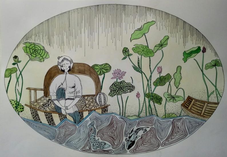
In the 1990s, with the development and prosperity of the economy and the improvement of environmental awareness, and the landscape industry has been greatly developed [1]. With the increasing frequency of international exchanges, many western landscapes design works have been introduced to China, which has aroused the strong interest of landscape architects. At the same time, many western cultural elements and some novel techniques have been widely used in domestic landscape design [2]. This phenomenon has brought many things that can be learned and referenced to domestic landscape design, but most of this learning and reference are only superficial, not comprehensive, and systematic. It is obviously a thousand-year-old country of oriental civilization. However, in many cities in China today, landscapes belonging to the European Baroque or ancient Roman style are built [3]. In terms of time, space, culture, and region, residents and tourists have caused different degrees of “travel” [4]. In recent years, domestic designers and related practitioners have realized that this model is instigating my country’s traditional national culture and regional cultural resources, while stifling the diversity and originality of global culture, breaking away from the national soil. Design will become a “four dissimilarities”. Therefore, inheriting and developing traditions is not a copy of the past, but to touch the basic points that transcend the times. It is to absorb the essence of traditional culture and art and convert into applicable a suitable expression for the new condition [5]. The traditional national culture is the thread of our descendants of Yan and Huang, and contemporary Chinese landscape design needs to take the local art form and aesthetic consciousness as the cornerstone of development. Common folk-art styles are shown in Figure 1.
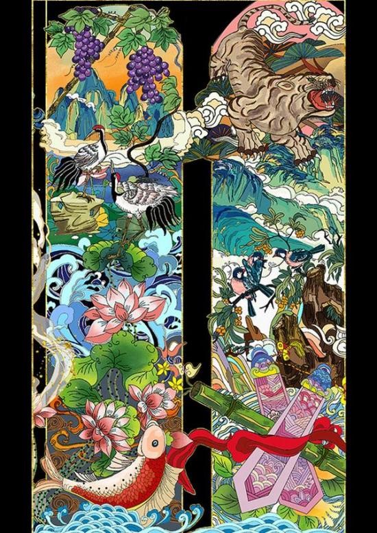
Folk art inherits the fine traditions of the Chinese nation, with various patterns and shapes and eclectic design styles. The creation of Chinese folk art is influenced by primitive thinking, traditional Chinese philosophical concepts, and folk beliefs, and is created according to their aesthetics, forming a variety of widely inherited folk-art shapes and folk auspicious patterns [6]. Its unique modeling methods, creative concepts, and reflected folk art modeling, patterns and patterns are valuable materials for our art design creation, which are worthy of our in-depth study and research [7]. The common landscape images in folk art works are shown in Figure 2.
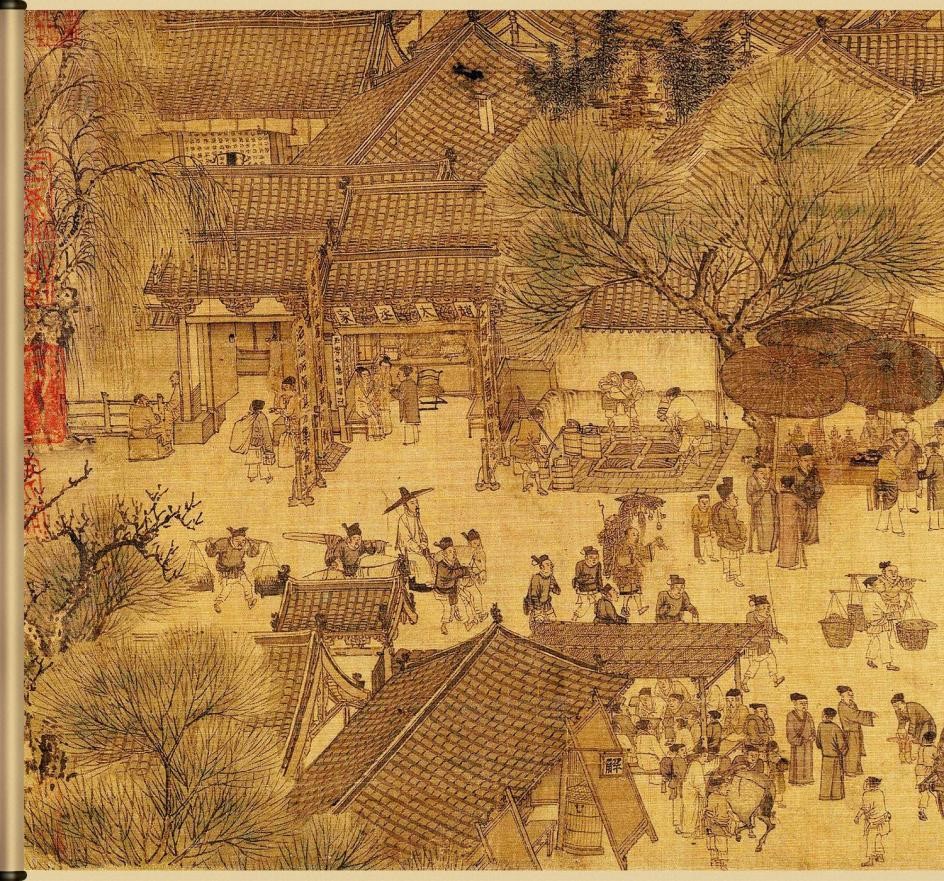
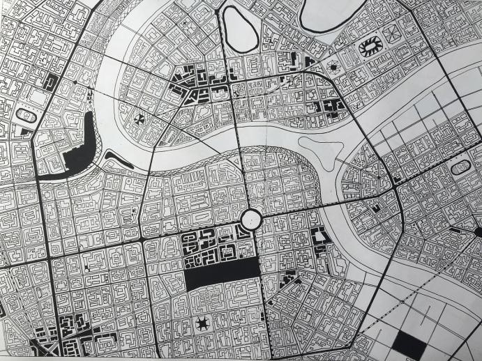
Taking Chinese folk-art works as an example, China, as the birthplace of Confucian culture and Qila culture, has a profound cultural heritage, and the folk art culture is a very bright stroke among them [8]. As shown in Figure 3, urban landscape design is integrated into the traditional Chinese artwork “Along the River During Qingming Festival”.
The rich cultural heritage and historical traditions in China have potential significance and significance to the innovation and development of modern art. Only by creating modern art design works with unique regional characteristics can we better inherit and carry forward Chinese folk art [9,10]. However, the breakthrough of science and technology and the innovation of cultural environment have led to the impatience and hesitation of the entire Chinese landscape design, and the spiritual aspect has also slowed down the pace of progress and even has the danger of stagnation. How to survive in this situation, let Chinese folk culture move into the future, and seek the integration of Chinese landscape material and culture has formed an important issue related to the lifeline of Chinese culture.
In order to prevent this series of “urban diseases” caused by the rapid development of cities, foreign scholars first proposed the concept of urban development of smart growth in the 1990s. A landscape is a geographic entity composed of a series of distinct land units or mosaics of ecosystems with distinct visual features. Landscape pattern refers to the composition and configuration of landscape [11].The change of urban landscape pattern fundamentally changes the process and function of the urban ecosystem [12], interferes and changes the material flow and energy flow of the ecosystem, and thus becomes the root cause of urban ecological environment problems [13]. Current research shows that: in terms of urban hydrological cycle, changes in urban landscape pattern lead to changes in the internal water balance of the city and increase in wetland water demand, such as the water demand for the basic flow of rivers, the water demand for groundwater recharge, and the water demand for purifying pollutants, surface runoff increases, resulting in the decline of wetland ecosystem services, urban non-point source pollution, urban flood disasters and other ecological and environmental problems; in terms of urban thermal cycle, after the impervious surface replaces green space, on the one hand, the internal transpiration of the city decreases, resulting in the internal The latent heat decreases and the color of the impermeable color becomes relatively darker, which reduces the reflectivity, and increases the specific emissivity, thermal conductivity, and heat capacity, resulting in an increase in the sensible heat inside the city. On the other hand, the higher the building height, the more significant the heat island effect [14]. The tall buildings in the city block the radiation of the earth, and the buildings radiate heat to the outside, which has a thermal insulation effect on the city, which together lead to the urban heat island; in terms of atmospheric circulation, green space has the effect of purifying pollutants, and the composition of green space and impermeable landscape At the same time, high-rise buildings affect the atmospheric circulation process of the city, hinder the diffusion of air pollutants in the city, and promote the formation of urban haze; in terms of biodiversity, the urban landscape pattern The changes in the original habitats of organisms have led to changes in the background of urban biodiversity, especially the introduction of vegetation-sensitizing species, which seriously threatens the health of urban residents.
Therefore, it is urgent to use the interactive genetic algorithm to study the symbolic value of folk art and urban landscape design. The embodiment and inheritance of the cultural symbols of Chinese folk art in landscape design is the focus of our in-depth and detailed research.
In the 1960s, the research on the dynamic change model of urban land began to rise. In the 1980s, American scholars put forward the basic theory of complexity science. The modeling of geographic information complex system, which combines the basic theory of complexity science with the laws of spatial and temporal dynamic changes of geography, is a research hotspot in this period. Since then, the research of urban dynamic model has become popular. In the first decade of the 21st century, [15] studies have shown that urban dynamic simulations and models have developed significantly during this period. According to the model principle, the dynamic models of urban land mainly include modeling based on mathematical equations, cellular automata model, multi-agent model, classification model and evolution model. At present, the combination of geospatial information technology and research model methods to solve complex geographic problems has become a research hotspot at home and abroad. [16] showed that in October 2010, NSF established the Cyberages project in the United States, and in April 2011, my country launched the “Earth System Simulator” scientific research project. High-performance geospatial computing and geographic computing intelligence provide new ideas and methods for urban system simulation. Recomputing is concerned with enriching geographic simulations and analyzing many highly complex, non-deterministic problems using a range of methods, and it is considered as a series of efficient programs or algorithms (such as neural networks, fuzzy logic, genetic algorithms, etc.) applied to geographic problems will inevitably produce results. [17] showed that the combination of recomputing and intelligent mining resulted in recomputing intelligence. China is in the stage of rapid urbanization. To solve various social and environmental problems in urban development, Chinese scholars attach great importance to the study of “simulation of dynamic changes in urban land use”. It can be seen that “simulation of dynamic changes of urban land” has been a major research issue in international geographic science and computer application technology since the 1960s, and a series of achievements have been achieved, which will inevitably generate new theoretical value and practical significance.
The urban dynamic model based on folk art is the key to the dynamic change simulation of urban land []. Based on the previous research results, the simulation models of dynamic changes of urban land are classified into 8 types according to the model principle: system dynamics model, model based on mathematical equations, empirical statistical analysis model, evolution model, expert model, self-based model. Models of agents, cellular automata models, and synthetic models. At present, the models widely used in the simulation of dynamic changes of urban land mainly include cellular automata model based on discrete grid action, system dynamics model based on complex system science, multi-agent model based on autonomous agent and Dyna based on empirical statistical analysis.
Not long after the CA model was first proposed in 1940 [19], Von Neumann used it to simulate the evolution of self-organizing complex systems, but limited by the development of computer technology at that time, the research and application of the CA model did not get great development. It was not until the 1970s that CA models were applied to the simulation of geographically complex systems. [20] applied the CA model for the first time to an extended simulation of the city of Detroit in the Great Lakes region of the United States. Later, [21] expounded the theoretical basis for the application of CA model in geographic simulation, which opened a new chapter for the widespread application of CA model in geographic simulation, especially in the dynamic simulation of urban land. GIS provides spatial data support for the CA model, and the CA model enhances the spatial modeling capabilities of GIS, thus the Geo-CA model is formally formed. In the 1990s, [22] used the Geo-CA model to simulate the origin and evolution of geographic complexity, which was a milestone in the study of the CA model.
But at the same time, there are few semiotics research works related to folk art design in China. [23] discussed the relationship between semiotics and design, which provides a reference for art design practice. The domestic landscape design discipline was born relatively late, with a history of only more than 20 years. In terms of theoretical research, it is still in the stage of introduction and digestion of foreign landscape theory, and it is popular, and the content is mostly practical design methods and techniques. In the current landscape design theory, more attention is paid to ecological issues, and there is relatively little research on landscape art. In academic papers, most of analyze Chinese classical gardens from the perspective of symbols.
To sum up, most of the studies on landscape art form still stay in the traditional empirical discussion or study from the external perspective such as geometry, and seldom use the research methods of symbolic aesthetics. The related research is mostly scattered in a few landscape theory research papers, and there is no research on landscape design from the perspective of folk art. Therefore, the research in this paper has a certain pioneering significance.
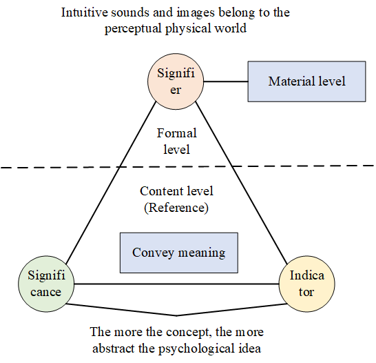
In 1894, he first proposed the concept of semiotics, pointing out that a sign consists of a signifier and a signified. In theory, the “signifier” is the external form of the symbol, which is a kind of intermediary. As shown in Figure 4. Only in special cases (when the two have some similarity), will the two have a direct relationship.
Folk art symbols are the carrier of folk culture spirit and thought, carrying people’s outlook on life, world outlook and values. Lange said: Art is the expression of emotion for people to watch, and it is the visible or audible form transformed from emotion. It is the use of symbols to transform emotion into something that appeals to human perception, rather than a symptom or something that appeals to reasoning ability. Art forms are isomorphic to the dynamic forms our sensory, intellectual and emotional lives have. Folk art symbols have a unique artistic expression, including symbolic functions such as reproduction and expression, in the final analysis, it is the expression of emotion. This kind of performance can outline an objective cognitive structure composed of cognition and emotion, which is not affected by other people’s emotions. Although folk art symbols can express the realm of beauty, their objective carrier, various specific things are in a dominant position. Limit the transmission of people’s general emotions.
Therefore, the folk-art symbols provide a new vision of the epistemology of folk art, which reduces the ultimate value and aesthetic essence of folk art.
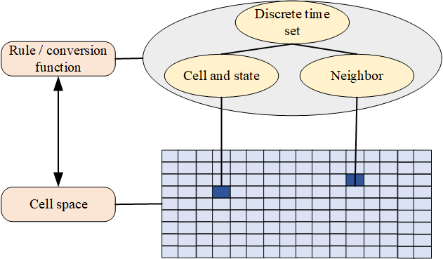
The CA model is a microscopic dynamic model with discrete time, space and state, and it is also a bottom-up evolution model with local spatial effects and temporal causality. A CA model usually includes five elements: cell, state, neighborhood, cell space, and transformation rules. The cell is the smallest unit of the CA model, the state is the attribute of the cell, the neighborhood refers to the surrounding cells centered on any cell, and the organization area of all the cells is the cell space. Through the current state of the central cell and its neighboring cells, the central cell can be converted to the next state. This conversion mechanism is called the conversion rule of the CA model. The composition organization of the CA model is shown in Figure 5.
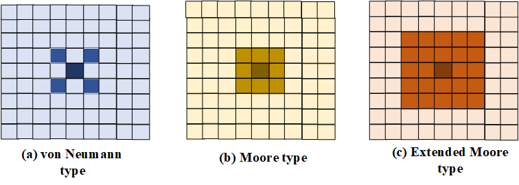
The cell space is organized by the collection of cells, which can reflect the geometric shape of the cell, the organizational structure of the cell collection and the spatial distribution. The common geometrical division of cell space is shown in Figure 6. Since quadrilaterals are easy to divide and understand, at the same time, quadrilaterals are easier to express in data structures than other shapes. Therefore, the most used cell space is the quadrilateral grid.
The transformation rules of the \(CA\) model are very important to it, and the transformation rules directly determine the evolution direction of the \(CA\) model. The transition rule of the \(CA\) model is generally to express the influence of the current state of the central cell and the current state of its neighbors on the next state of the central cell through a state transition function. The state transition function can be abbreviated as:
\[\label{e1} f:s_i^{t + 1} = f\left( {s_i^t,s_N^t} \right).\tag{1}\]
The evolution of landscape pattern is a direct reflection of land use cover change. Therefore, factors affecting land-use cover change can be mapped to the evolution of landscape patterns. The driving factors of urban land use cover change are diverse, and factors such as natural, social and economic factors can have a significant impact on the dynamic changes of urban land use. For example, factors such as elevation, slope, undulation, distance from urban centers at all levels, distance from rivers and water bodies at all levels, distances from roads and railways at all levels, surrounding construction land ratio, population density, and GDP may all have a negative impact on cities. The dynamic change of land use and even the evolution of urban landscape pattern cause large or small, positive or negative driving effects. The flow chart of its landscape verification algorithm is shown in Figure 7.

There are many ways to evaluate the landscape pattern, and the most common one is to use the landscape pattern index. Landscape pattern indices are also classified into categories, including indices based on spatial statistics, indices based on information theory, indices based on spatial correlation, and indices based on patch shape characteristics. Although there are many types and numbers of landscape pattern indices, many indices are highly correlated, resulting in similar expression results of their respective evaluations. At the same time, selecting these indices with greater correlation cannot add additional evaluation information. Therefore, it is very important to select effective and comprehensive landscape pattern evaluation indicators to correctly evaluate the urban landscape pattern.
In this paper, all Landsat apparent reflectance products covering the study area during the study period are selected as the original data See Table 1 for specific data sets.
| Sensor | Dataset name | Get period | Number of bands |
|---|---|---|---|
| TM | USGS Landsat 7 | 1986.01.01-2011.12.31 | 7 + boa (quality control band) |
| ETM+ | USGS Landsat 8 | 2012.01.02-2013.12.31 | 9+BQA |
| OLI | TOA Reflectance | 2014-01.01-2013.12.31 | 11+BQA |
The experimental data are divided into two categories: driving factor data and remote sensing land data. Among them, the remote sensing land data uses the Landsat TM data in 2018 and 2021 as the base year and target year data of the simulation, respectively. The basic data of driving factors mainly include DEM data from the University of Maryland Geoscience Data Set (GLCF); vector data of town and town center points from open street view maps, vector data of roads, railways and river lines; remote sensing land data. A basic description of all underlying data is shown in Table 2.
| Data source | Data type | Resolution scale | Main purpose |
| Remote sensing data in 2018 | Landsat TM (2018) | \(30m \times 30m\) | Land use type extraction, neighborhood driver extraction in 201800 |
| Remote sensing data in 2021 | Landsat TM (2021) | \(30m \times 30m\) | Land use type extraction, neighborhood driver extraction in 2021 |
| Administrative division data | Surface vector data | 1:1ten thousand | Determine the scope of the study area |
| DEM data | Raster data | \(30m \times 30m\) | Elevation and slope driving factor extraction |
| National water system data | Line vector data | 1:1ten thousand | Extraction of distance driving factors from rivers |
| National road data | Line vector data | 1:1ten thousand | Extraction of distance driving factors from highways and railways |
| Administrative center data | Point vector data | 1:1ten thousand | Extraction of driving factors of distance from the centers of towns and townships at all levels |
Use ArcGIS to process the DEM data required for the experiment to obtain elevation and slope layers. The collected administrative divisions and Open Street View vector data were processed in ArcGIS to obtain distance to market, distance to road, and distance to river layers. To reduce the amount of data, the three factors are calculated by using weighted summation to calculate the Euclidean distance. For example, the distance to Chengdu and Chongqing city center accounts for 50% of the weight, and the distance to other prefecture-level cities in the study area is weighted 50%. The weight of the distance to the center is 30%, the weight of the distance to the center of the district and county in the study area is 15%, and the weight of the distance to the center of the township in the study area is 5%. Likewise, the distance to the road and the distance to the river are calculated in this way. The collected two-phase remote sensing land use classification data of the base year and the target year are processed in ENVI and ArcGIS to obtain construction land and non-construction land, and detect land use changes, that is, urban expansion Happening. In addition, the remote sensing land data of the base year is used for grid calculation, and the construction land neighborhood of each grid is obtained. Use ArcGIS to normalize the data obtained above, and then use SPSS to analyze the correlation between the normalized driving factor data and land use changes to verify the validity of the selected driving factors. The urban land dynamic simulation experiment data is processed to obtain 6 driving factors, two phases of remote sensing land use data and land use change detection data map as shown in Figure 8.
Traditional urban land dynamic simulation research generally takes a single city or multiple urban areas as an example in a relatively small area, while the research area in this paper is a relatively large geographical area with a large amount of data, and the focus of the urban dynamic simulation in this paper is to focus on the dynamic expansion of urban and rural construction land. Therefore, this paper simplifies the types of urban land into two types. The mathematical principles of logistic regression and its advantages and disadvantages have been introduced in the overview of the basic principles in Eq. (2). From the above, we know that the logistic regression classifier is very suitable for nonlinear binary classification problems. In this paper, the urban land in the Chengdu-Chongqing Economic Zone is Dynamic simulation research is exactly such a problem. According to the classification threshold of logistic regression, the classification result can be expressed as:
\[\label{e2} F=\left\{\begin{array}{l} \text { Construction land, } 0.5 \leq f(t) \leq 1, \\ \text { Non construction land, } 0 \leq f(t)<0.5. \end{array}\right.\tag{2}\]
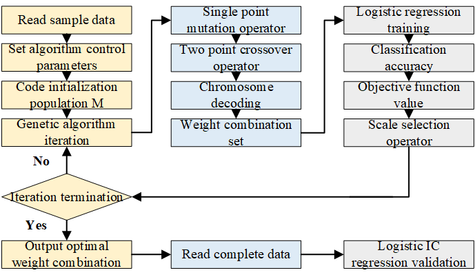
The regression coefficient flow of genetic algorithm optimization of logistic is shown in Figure 9.
The fitness function of the genetic algorithm directly determines the iterative development of the genetic algorithm in the direction of increasing the average fitness value of the population, and finally the individual with the largest fitness, that is, the optimal individual. Therefore, the design of the fitness function is crucial. In the constructed GA-logistic regression model, the fitness function of the genetic algorithm is designed as the classification accuracy of the sample data during the logistic regression training process. The fitness calculation is expressed as the Eq. (3):
\[\label{e3} \text{Fit}\frac{{{p_1} + {p_2}}}{\text{pall}}.\tag{3}\]
Therefore, the mutation operation with an adaptive mutation rate from small to large is more suitable for genetic algorithm iteration. In the constructed GA-logistic regression model, the genetic algorithm implements adaptive crossover operator and mutation operator.
\[\label{e4} {p_c} = p{c_1} – \left( {p{c_2} – p{c_1}} \right)*\frac{{{\text{ popsize }} – n}}{{{\text{ popsize }}}}.\tag{4}\]
\[\label{e5} {p_m} = p{m_1} + \left( {p{m_2} – p{m_1}} \right)*\frac{{{\text{ popsize }} – n}}{{{\text{ popsize }}}}.\tag{5}\]
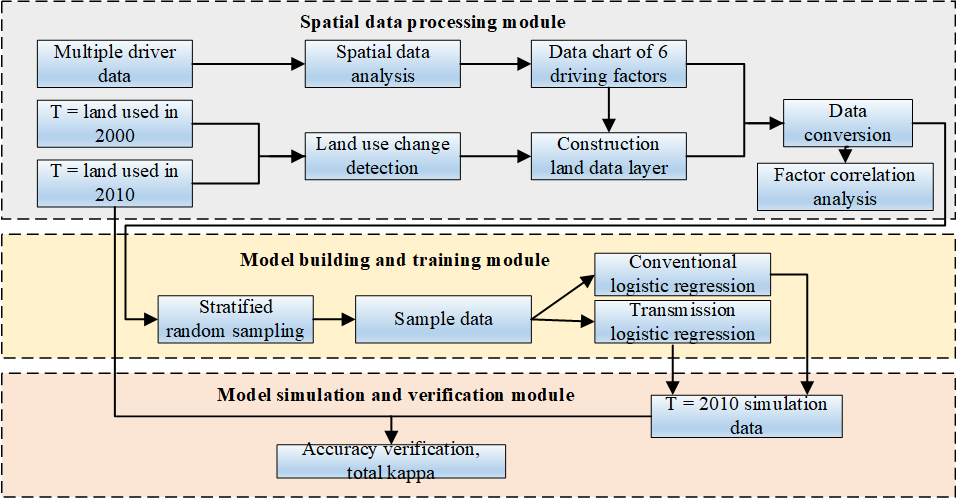
The verification of the model is mainly achieved by comparing the land use distribution in the target year with the simulation results. The connection process of the three modules is: the transformed data in the spatial data processing part will be stratified and randomly sampled to obtain sample data; the model building and training part uses the sample data to train the constructed integrated model; the model simulation and verification part A confirmatory simulation of the model trained in the previous section is performed and compared with the simulation effect of the conventional logistic regression model. The technical route of dynamic simulation of urban land is shown in Figure 10.
The genetic algorithm of folk art in urban landscape design can converge after the maximum number of iterations, and the population mean of the objective function can approach zero, and a set of optimal weight combinations can be obtained to make the prediction error rate of the sample data tend to be. Close to zero, the optimal weight combination is the optimal regression coefficient of the logistic regression classification model. The convergence curve of the genetic algorithm is shown in Figure 11.

Based on the above conclusions, a logistic regression model trained based on GA is used to predictively simulate the future distribution and quantity of urban land. Based on the base year of 2020 and the target year of 2021 in this paper, the map of urban land use in 2020 with equal time-year intervals is shown in Figure 12. Through the quantitative statistics of the ArcGIS attribute table, the urban and rural construction land increased from 50,622 grids in 2000 to 66,699 grids in 2020, and increased to 82,784 grids in 2021, with growth rates of 31.8% and 24.1%.
In conclusion, this chapter is the core part of the full text. First, the conventional logistic regression model suitable for nonlinear binary classification simulation of urban construction land expansion is introduced. However, due to the limitations of conventional logistic regression models, this paper constructs a GA-logistic regression model in which a genetic algorithm is used to optimize the regression coefficients of the logistic regression model. Then, the process of constructing the GA-logistic model is introduced in detail. The design of the fitness function of the genetic algorithm and the adaptive crossover operator and mutation operator in the model is introduced. The technical route and experimental plan of the dynamic simulation of urban land are designed. Through the simulation accuracy and total kappa and comparative simulation experiments, the advantages of the GA-logistic regression model compared with the conventional logistic regression model can be verified. Finally, a predictive simulation of future urban land use was performed using the model.
The main research work of this paper is to model, simulate, predict and evaluate the landscape pattern of urban land dynamics on the basis of folk-art symbols. First of all, this paper summarizes and summarizes on the basis of scholars’ research and selects logistic regression as the basic model for dynamic simulation of urban land according to the characteristics of the research area in this paper. However, when the conventional logistic regression based on maximum likelihood estimation is faced with extremely unbalanced data distribution in the study area and many data features, the model fitting ability becomes weak. Therefore, this paper seeks an optimization method for obtaining logistic regression coefficients to avoid the parameter under-fitting problem that is prone to occur in logistic regression based on maximum likelihood estimation. As an efficient global optimization algorithm, the genetic algorithm will have a good effect on the optimization of logistic regression coefficients.
The experimental data used to support the findings of this study are available from the corresponding author upon request.
Author declares no conflicts of interest regarding this work.