
In recent years, with the rapid development of China’s economy and the steady rise of the national economy, the environmental protection and ecological balance of most areas have been exposed, especially the serious situation of the rural ecological environment has become more and more serious. For the promotion of rural economic development, the construction of rural ecological environment is of great significance, therefore, it is urgent to solve the problem of rural ecological environment protection. How to effectively improve the rural environmental situation and protect the rural ecological environment will be a regular problem faced by today’s society [4,19,9].
Insufficient awareness of rural ecological environment protection is a prominent problem facing rural ecological environment protection at present. In some areas, farmers’ awareness of ecological environmental protection still remains in the traditional production and life style, and they lack the awareness of the importance and urgency of ecological environmental protection. This has led to the insufficient promotion of rural ecological environmental protection, and the phenomenon of destroying the ecological environment has even occurred in some places [18,17]. In order to improve the awareness of rural ecological environmental protection, it is indispensable to strengthen the publicity and education work, enhance the legal construction of rural ecological environmental protection, and promote the green development of rural areas. Strengthening the legal system is an important foundation, through the legal system to improve the rural ecological environmental protection laws and regulations, clear responsibility for rural ecological environmental protection of the main body and specific measures, increase the penalty for illegal behavior, the formation of effective constraints on the rule of law, and to strengthen the law enforcement and supervision, to ensure the effective implementation of laws and regulations [14,5,2].
[21] emphasized that the environmental problems in rural areas lie in the imperfection of the legal mechanism and the lack of environmental awareness. It also discusses the achievements, problems and improvements in the legal construction of rural environmental protection, aiming to improve the current situation of rural environment. [10] pointed out the importance of rural environment to biodiversity, based on the analysis of rational rural spatial environment layout, the development of bio-agriculture and other paths in order to realize the protection of biodiversity in the construction of rural environment. [1] affirmed the important role of wildlife protection issues on ecological security in western ethnic minority areas, stating that wildlife protection is the result of the joint efforts of many parties, including the improvement of the government’s awareness of ecological security precautions as well as the construction of ecological and environmental legal system in ethnic areas. [16] summarized the current situation of environmental protection in rural China and the challenges it faces compared with urban environmental protection. It also examines the causes of urban-rural environmental inequality, and proposes a BUREP strategy and framework based on urban-rural environmental inequality, which is of some reference value for the decision-making of integrating urban-rural environmental protection and the construction of new rural areas. [11] systematically analyzed the European Parliament and Council on EAFRD support for rural development rural development program. It is indicated that the constitutional principle of environmental protection is respected in Poland when developing important high budgetary instruments for the implementation of development policies. [22] pointed out that the shortcomings of the environmental legal system in China lead to difficulties in achieving the goals of national environmental legislation. By proposing a comprehensive review of lower-level environmental laws and strengthening the leading role of local people’s congresses in environmental legislation, it aims to help China build an effective environmental legal system. [8] explored the ecological strategy of rural nature conservation environment based on information system. The main functions of designing a rural environmental information system are discussed in terms of designing the main functions of a rural environmental information system based on the characteristics of a village, such as geographic information system technology, computer technology, and so on. The results show that the system can accurately analyze the rural environment.
[7] emphasized the important role of the circular economy for the economy, environment and society in the western region, and pointed out the factors that constrain the development of the circular economy in the western region, and put forward the suggestions of establishing a correct view of development, reinforcing the concept of the circular economy, strengthening law enforcement, and carrying out publicity on environmental protection. [3] examined the impact of the campaign-style governance approach on the legislative process related to nature conservation using the difference method with the Central Inspectorate of China’s Environmental Protection as an experiment. It was found that the overall quantity and quality of local environmental protection laws enacted under the campaign-style governance approach increased significantly and produced favorable judicial consequences. [12] emphasized the seriousness of rural environmental problems, which even with some salvage measures, have had very poor results. Therefore, it is necessary to take comprehensive measures to establish and improve the long-term mechanism of rural environmental protection in a comprehensive and systematic way. It also describes the favorable situation in recent years, such as the rural environment has achieved comprehensive improvement and garbage pollution has been controlled. [6] described the effectiveness of green sustainable development in a village in Guizhou, pointing out that the villagers of the village formulated the “villagers’ self-governance agreement”, which stipulates that the villagers and the village committee have the obligation to protect the environment, and there is a penalty for the damage to the environment, which has had a positive impact on the protection of the environment in the countryside. cite20 showed the importance China attaches to rural revitalization, and based on the legal issues in the development of rural urbanization, it discusses rural planning, environmental protection and other aspects, and analyzes rural planning, the construction of a livelihood guarantee system, and environmental protection in rural tourism.
In this paper, Ganzhou District was selected as the research object, and the geographic profile of Ganzhou District was summarized. Kernel density estimation, standard deviation ellipse, mean nearest neighbor and geoprobe were used to explore the rural ecological distribution characteristics and the spatial differentiation of rural ecosystems and the response to change in Ganzhou District. The rural ecological spatial distribution characteristics and rural ecological discrete-aggregation degree in Ganzhou District were revealed. The connection between different influencing factors and rural ecosystem differentiation is deeply excavated. The changing law of ecosystems and the response of land use in Ganzhou District are deeply understood. Optimization direction is proposed for the problems of rural ecosystem protection in Ganzhou District, and the legal guarantee system of rural ecological environment is improved by taking the region as an example.
Ganzhou District is located between 100\(\mathrm{{}^\circ}\)04’E-100\(\mathrm{{}^\circ}\)52’E, 38\(\mathrm{{}^\circ}\)32’N-39\(\mathrm{{}^\circ}\)24’N, in the central part of the Hexi Corridor, the northern foothills of the Qilian Mountains, the southern edge of the Badanjilin Desert, belonging to the city of Zhangye, neighboring the county of Shandan to the east, bordering the county of Linze to the west, relying on the Minle County to the south, and bordering the banner of Right Banner of Alashan to the north. It is 98km wide from north to south and 65km long from east to west, covering an area of 3661.23km².
Ganzhou district topography by the northern Haili Mountain, Longshou Mountain, the central corridor plains composed of the southern Qilian Mountains. The terrain is high in the north and south, low in the middle, from southeast to northwest tilted basin, elevation between 1400-2000m, with a unique corridor topography and desert oasis scene, the corridor oasis basin terrain is flat, fertile soil, the Black River runs through the whole territory, irrigation conditions are convenient, is the main farming areas in this district.
Soil types include oasis irrigation silt soil, tidal soil, wind sandy soil, gray-brown desert soil, chestnut calcium soil, gray calcium soil, meadow soil, salt soil, subalpine meadow soil, and gray-brown soil in 10 categories, of which the distribution area of gray-brown desert soil accounts for 47.1% of the area of the whole region. Vegetation types include plains and mountain forests, desert scrub grasslands, meadows and swamps.
According to the meteorological observation data of the Chinese Academy of Sciences for many years, the annual average temperature in Ganzhou District varies from 3.5\(\mathtt{{}^\circ\!{C}}\) to 8.0\(\mathtt{{}^\circ\!{C}}\). Temperature distribution in the trend of southeast-northwest direction, from the plains and basins to the mountains gradually decreasing. Solar radiation is weakest in winter, controlled by Mongolian high pressure and strong winds. Winter temperatures are the lowest, with the coldest month occurring in January. In summer, solar radiation is the strongest, and the surface has the strongest ability to heat the atmosphere; summer temperatures are correspondingly the highest, with the hottest month occurring in July. The climate is typical of temperate continental climate.
The spatial distribution of precipitation in Ganzhou District is generally decreasing from southeast to northwest. The average annual precipitation in Ganzhou District is 130.1mm, with the highest precipitation occurring in July and August in summer and the lowest in December and January in winter. In the summer, the airflow from the south and east prevails over the area, and the ground is controlled by low pressure, so the climate is relatively warm and humid, and there is more precipitation. In winter, northwestern air currents prevail at high altitude, and the ground is controlled by the strong Mongolian high pressure, so the climate is dry and precipitation is scarce.
Ganzhou District is the seat of the CPC Zhangye Municipal Committee and Municipal Government, as well as the political, cultural and economic center of Zhangye City. The district has 245 immovable cultural relics of past dynasties, including 10 national key cultural relics protection units. Sui Dynasty wooden tower, Ming Dynasty bell tower, Xixia Dafo Temple and other attractions, inherited the historical lineage, showing different periods of the times and cultural connotations, constituting a unique cultural concepts, not only is a veritable ancient city, but also Gansu Huaxia Civilization Inheritance and Innovation Zone – an important node of the Silk Road Cultural Development Belt, but also the country’s important ecological security barrier in the western part of the country, and even more so, statistical analysis, Ganzhou District, 2009- Moreover, the statistical analysis shows that the ecological environment condition index of Ganzhou District from 2009 to 2013 is between 31.29 and 33.19, and the ecological environment quality condition level is “poor”, which indicates that the vegetation cover is poor, severe drought and low rainfall, and fewer species, and there are obvious factors limiting the life of human beings.
The ecological environment status index for 2012-2022 ranges from 39.52 to 41.97, with an ecological environment quality level of “average”, which indicates a medium level of vegetation cover and an average level of biodiversity that is more suitable for human survival. This marks a significant shift from an ecological condition index of less than 35 (the threshold between “poor” and “average” levels) to more than 35 in 2014 in Ganzhou District, Zhangye City. At the same time, the change value of the ecological environment status index is more than 8, corresponding to the level of change of the ecological environment status is “significant change”, which indicates that the ecological environment quality of Ganzhou District has significantly improved, and the ecological environment has gradually stepped into the benign cycle track.
Because of the small scope of the study area and the complicated data sources with different unit sizes, all the spatial data are unified with a resolution of 30m in order to facilitate the unified calculation, which is used as the basic evaluation unit of Ganzhou District. The 2000 national geodetic coordinate system was used as the basis to unify the projection coordinate system of all kinds of spatial data.
Points of interest (POI), in GIS, generally refer to those kinds of entities that can be abstracted into point-like representations. Companies, shopping malls, schools, parks, etc. in real life all belong to the POI category. Each POI data contains at least basic information such as the category, address, latitude and longitude coordinates, and name of the geographic entity, etc. The POI data is huge in quantity, covering all aspects of the city, and provides rich data support for urban research. In this paper, POI data provided by Gaode map is used to identify the outer boundary of the urban fringe area in Ganzhou district. The data is based on crawler software and obtained by calling the API interface provided by Gaode Map. Impervious surface selected in this paper refers to a type of cover that is constructed by hand and used to effectively prevent rainwater from infiltrating into the ground surface. The increase in the percentage of impervious surface is usually regarded as one of the distinctive features of regional urbanization process. Since Landsat remote sensing image data have rich spectral band information and high spectral resolution, they are suitable for impervious surface extraction. In this paper, based on the 2020 Landsat8 remote sensing image data obtained from Geospatial Data Cloud, the remote sensing image is preprocessed, which includes the steps of image geometric correction, alignment, and atmospheric correction, etc. The preprocessing process is realized based on the digital image processing platform ENVI5.1.
Based on the Classification of Land Use Status Quo, this paper extracts the land use types in Ganzhou District by using Landsat5 and Landsat8 remote sensing images as data sources, taking into full consideration of the distribution of land resources and the characteristics of the natural environment in Ganzhou District. According to the classification standard, the land use types are divided into five major categories: cropland, forest land, grassland, watershed, and construction land. While comprehensively considering the brightness, hue, and structure of remote sensing images, scientific and reasonable interpretation signs are established by combining the geographic area characteristics of Ganzhou District and the features of each land use type. To this end, this paper firstly selects a sufficient number of training samples for interpretation annotation based on ENVI5.1, and secondly adopts the maximum likelihood method to extract land use type information from the two remote sensing images of Ganzhou District. The interpretation results of the two periods of remote sensing images of Ganzhou District in 2005 and 2020 are obtained.
The study area boundary, road network and other data applied in this paper are from the national basic geographic information database 1:1 million national basic data.
Kernel density estimation [15] is a method in spatial interpolation that uses some of the characteristics of the spatial data itself (e.g., proximity, directionality, etc.) to interpolate the spatial data so that the density of its centroid is maximized. Kernel density estimation generates a continuous density analysis surface by calculating the degree of discretization of the data through the number of input data. The density is obtained by calculating the density, distributing the density value of each point over the study area, and finally obtaining the image element value of each raster. According to the probability theory, the kernel density estimation model is: \[\label{GrindEQ__1_} f_{n} (x)=\frac{1}{nh} \sum\limits_{i=1}^{n}k\left(\frac{x-x_{i} }{h} \right) , \tag{1}\] where \(k\left(.\right)\) is the kernel function, \(h\) is the bandwidth, \(h\left(29\right)0\), \(x-x_{i}\) is the distance from valuation points \(x\) to \(x_{i}\). In kernel density estimation, 2 parameters need to be set for the output image size and search radius; the larger the search radius, the smoother the density grid and the higher the degree of generalization, and the smaller the search radius surface, the more detailed the information generated.
The standard deviation ellipse [20] is a spatial statistical method used to analyze the spatial distribution of the elements in the space of the characteristic distribution center can reflect the degree of dispersion of the spatial distribution of the elements. The azimuth indicates the main trend, the long axis indicates the degree of dispersion of the elements in the direction of the long axis, and the short axis indicates the range of the distribution of the object. The relevant calculation formulae are as follows:
Mean center is: \[\label{GrindEQ__2_} \begin{array}{l} {\bar{X}_{w} ={\sum\limits_{i=1}^{n}w_{i} x_{i} \mathord{\left/ {\vphantom {\sum\limits_{i=1}^{n}w_{i} x_{i} \sum\limits_{i=1}^{n}w_{i} }} \right. } \sum\limits_{i=1}^{n}w_{i} } } ,\\ {\bar{Y}_{w} ={\sum\limits_{i=1}^{n}w_{i} y_{i} \mathord{\left/ {\vphantom {\sum\limits_{i=1}^{n}w_{i} y_{i} \sum\limits_{i=1}^{n}w_{i} }} \right. } \sum\limits_{i=1}^{n}w_{i} } } .\end{array} \tag{2}\]
Azimuth is: \[\label{GrindEQ__3_} \tan \theta =\frac{\left(\sum\limits_{i=1}^{n}w_{i}^{2} \bar{x}_{i}^{2} -\sum\limits_{i=1}^{n}w_{i}^{2} \bar{y}_{i}^{2} \right)+\sqrt{\left(\sum\limits_{i=1}^{n}w_{i}^{2} \bar{x}_{i}^{2} \right)^{2} +4\sum\limits_{i=1}^{n}w_{i}^{2} \bar{x}_{i}^{2} \bar{y}_{i}^{2} } }{2\sum\limits_{i=2}^{n}w_{i}^{x_{i} \bar{y}_{i} } } , \tag{3}\]
The \(x\)-axis and \(y\)-axis standard deviations are as, respectively: \[\label{GrindEQ__4_} \sigma _{x} =\sqrt{\sum\limits_{i=1}^{n}{\left(w_{i} \bar{x}_{i} \cos \theta -w_{i} \bar{y}_{i} \sin \theta \right)^{2} \mathord{\left/ {\vphantom {\left(w_{i} \bar{x}_{i} \cos \theta -w_{i} \bar{y}_{i} \sin \theta \right)^{2} \sum\limits_{i=1}^{n}w_{i}^{2} }} \right. } \sum\limits_{i=1}^{n}w_{i}^{2} } } , \tag{4}\] \[\label{GrindEQ__5_} \sigma _{y} =\sqrt{\sum\limits_{i=1}^{n}{\left(w_{i} \bar{x}_{i} \sin \theta -w_{i} \bar{x}_{i} \cos \theta \right)^{2} \mathord{\left/ {\vphantom {\left(w_{i} \bar{x}_{i} \sin \theta -w_{i} \bar{x}_{i} \cos \theta \right)^{2} \sum\limits_{i=1}^{n}w_{i}^{2} }} \right. } \sum\limits_{i=1}^{n}w_{i}^{2} } } , \tag{5}\] where \(\left(x_{i} ,y_{i} \right)\) represents the spatial coordinates of the geographic object, \(w_{i}\) represents the weight, \(\left(\bar{X}w,\bar{Y}w\right)\) represents the weighted average center of the object, \(\theta\) is the azimuthal angle of the standard deviation ellipse, \(\bar{x}i\) and \(\bar{y}i\) are the coordinate deviation of each geographic object to the weighted average center, and \(\sigma x\) and \(\sigma y\) represent the standard deviation along the short axis \(x\) and the long axis \(y\), respectively.
Average nearest neighbor analysis, consists of three main steps: 1) Measure the distance between the center of mass of each element and the location of the center of mass of its nearest neighboring element. 2) Calculate the average of all these nearest neighbor distances. 3) If the average distance is smaller than the average distance in the hypothesis, the analyzed elements are considered to exhibit clustered distribution characteristics. If the average distance is greater than the average distance in the hypothesis, it is considered that the analyzed elements present a dispersed distribution characteristic. The average nearest neighbor ratio is calculated by the formula: \[\label{GrindEQ__6_} ANN=\frac{\overline{D_{o} }}{\overline{D_{E} }} , \tag{6}\] where \(\overline{D_{o} }\) is the average of the distances between the measured elements and their nearest neighboring element centers is: \[\label{GrindEQ__7_} \overline{D_{O} }=\frac{\sum\limits_{i=1}^{n}d_{i} }{n} . \tag{7}\] \(\overline{D_{E} }\) is the elemental randomly distributed mean distance defined as: \[\label{GrindEQ__8_} \overline{D_{E} }=\frac{0.5}{\sqrt{\frac{\pi }{4} } } . \tag{8}\]
Note that, \(d_{i}\) is the distance between element \(i\) and its nearest neighbor, \(n\) is the number of elements in a certain area, and \(A\) is the area of the envelope of all elements.
Geodetector [13] is a spatial analysis method to detect spatial variability and reveal the driving force behind it, and its main advantage is that it can detect single-factor effects, as well as factor interactions, and it contains four detectors, namely, factor detection, interaction detection, risk zone detection, and ecological detection. Referring to the relevant literature and combining the natural, climatic, and human characteristics of Jilin Province, this study selected seven indicators of NDVI, NPP, annual precipitation, average temperature, population density, elevation, and slope, which have obvious spatial differences, to analyze them, and used the factor detector to determine the degree of explanation of spatial variation of habitat quality by a single driver, and used the interaction detector to determine the existence of the interactive explanatory ability between two or two drivers. The interaction was categorized into five types: independent, two-factor enhancement, nonlinear enhancement, nonlinear attenuation, and one-factor nonlinear attenuation, and the calculation formula is as follows: \[\label{GrindEQ__9_} q=1-\frac{\sum\limits_{h=1}^{L}n_{h} \sigma _{h} {}^{2} }{n\sigma ^{2} } , \tag{9}\] where \(q\) is the degree of explanation of the driver, \(n_{h}\) and \(\sigma _{h}\) are the sample size and variance of the driver in stratum \(h\), and \(n\) and \(\sigma ^{2}\) are the total sample size and variance. The value of \(q\) ranges from \(\left[0,1\right]\), with larger values indicating a higher degree of explanation.
The distribution of the five types of rural ecology in the regions varies to different degrees, which indicates that, despite the richness and diversity of ecological resources in the Ganzhou district slice, their distribution in the slice is not balanced. The distribution of ecological resources in the region is shown in Table 1, specifically, there are 819 rural ecological areas in the slice of the region, which are, in order of number: counties A, F, G, E, B, C, D and H. Among the five categories of rural ecology, the farmland ecology category has the largest number of rural ecology, with a total of 601, which is inseparable from the long history and splendid civilization of the area, of course, the differences in the distribution of farmland ecology category rural ecology are also very much related to the historical evolution, and at the same time, this is also closely related to the level of ecological development of the area.
| County | Natural landscape ecology | Water ecology | Bioecology | Forest ecology | Farmland ecology |
| A | 15 | 10 | 21 | 6 | 136 |
| B | 10 | 1 | 8 | 8 | 82 |
| C | 11 | 1 | 3 | 9 | 65 |
| D | 1 | 0 | 2 | 4 | 28 |
| E | 8 | 4 | 14 | 15 | 70 |
| F | 14 | 5 | 11 | 7 | 122 |
| G | 8 | 2 | 9 | 7 | 87 |
| H | 0 | 1 | 0 | 3 | 11 |
| Total | 67 | 24 | 68 | 69 | 601 |
Through the standard deviation ellipse analysis method, the collected POI big data were visualized and analyzed in Arc GIS10.2, and the spatial distribution of the 5 types of rural ecology in the municipalities of Ganzhou District was clearly understood, and the spatial distribution of the rural ecology in Ganzhou District is shown in Table 2. From the shape of the standard deviation ellipse, the distribution direction of the 5 categories of rural ecology are all in the northwest-southeast direction, which is relatively consistent with the overall regional pattern of the district. From the length of the X-axis, in order of length, they are: forest ecology, farmland ecology category, biological ecology, natural landscape ecology, and water ecology. In other words, from long to short, the direction of rural ecology gradually decreases. It can be seen that the distribution direction of rural ecology in the forest ecology category is the most obvious, the distribution direction of rural ecology in the watershed ecology category is the least obvious, and the distribution direction of the other types of rural ecology is between the two, but the distribution of the direction of all the types is in a northwesterly-southeasterly direction.
| Ecological type | X axis length/km | Y axis length/km | Central Angle X | Central Angle y | Deflection\(\theta\)/(\(\mathrm{{}^\circ}\)) |
| Farmland ecology | 1.916 | 0.762 | 104.666 | 35.693 | 103.509 |
| Water ecology | 1.509 | 0.613 | 104.095 | 35.626 | 113.825 |
| Bioecology | 1.792 | 0.822 | 104.543 | 35.648 | 108.431 |
| Forest ecology | 2.045 | 1.01 | 104.886 | 35.7 | 101.458/ |
| Natural landscape ecology | 1.669 | 0.832 | 104.603 | 35.655 | 107.948 |
In terms of the length of the Y-axis, in order of length, they are: forest ecology, natural landscape ecology, bio-ecology, agro-ecology category, and water ecology.Changes in the length of the Y-axis can be deduced to indicate the distribution range of each rural ecology and whether its centripetal nature is obvious or not. The analysis shows that the Y-axis of forest ecology rural ecology is the longest, indicating that it has the widest distribution range within Ganzhou district, but its centripetal nature is the least obvious. On the other hand, the watershed ecological rural ecology has the highest degree of distributional agglomeration and the most obvious centripetalism. The remaining types of rural ecology are in between. From the angle of deflection of the ellipse, in order of magnitude of the angle of deflection, they are: watershed ecology, bio-ecology, natural landscape ecology, agro-ecological category, and forest ecology. Water ecology rural ecology has the largest deflection angle of 113.825, which is closely related to the distribution of rivers. Forest ecology has the smallest ecological deflection angle of 101.458. As an area of ethnic integration in history and due to past wars and disputes, the area is scattered with rich military sites such as the Great Wall.
The Arc GIS 10.8 software was used to analyze the nearest neighbor index of rural ecology in 16 townships in Ganzhou District. The nearest neighbor index analysis is based on the ratio of the actual average distance between each element and its nearest neighbor element to the ideal average distance in the state of random distribution, and the more the ratio tends to be close to 0, which indicates that the elements are more concentrated, and it has been concluded that the spatial distribution of the point elements is of the uniform type when R\(\mathrm{>}\)1. When R=1, the spatial distribution of point elements is randomized. When R\(\mathrm{<}\)1, the spatial distribution of point elements is cohesive. The Z and P values returned by the results of the nearest neighbor index analysis are used to test the degree of deviation of the measured average distance from the expected average distance. The final results are shown in Table 3, which shows that the rural ecology within the 16 townships of Ganzhou District, in the case of P=0, the nearest neighbor index value is less than 1 is, Township C, Township D, Township E, Township H, Township L, Township M, and Township N, which indicates that all of them are in the mode of cohesive distribution and the relationship between the size of the degree of cohesion is as follows: Township D\(\mathrm{>}\)Township N\(\mathrm{>}\)Township L\(\mathrm{>}\)Township M\(\mathrm{>}\)Township H\(\mathrm{>}\)Township C\(\mathrm{>}\)Township E.
| Town | Proximate ratio | Z score | P value |
| A | 1.846 | 4.512 | 0.000 |
| B | 1.753 | 4.485 | 0.000 |
| C | 0.625 | -4.896 | 0.000 |
| D | 0.471 | -4.06 | 0.000 |
| E | 0.689 | -3.558 | 0.000 |
| F | 2.256 | 6.548 | 0.000 |
| G | 351.244 | 948.652 | 0.000 |
| H | 0.612 | 2.215 | 0.000 |
| I | 1.065 | 0.283 | 0.623 |
| J | 1.078 | -0.254 | 0.759 |
| K | 1.028 | 0.116 | 0.915 |
| L | 0.518 | -7.158 | 0.000 |
| M | 0.564 | -9.265 | 0.000 |
| N | 0.512 | -4.025 | 0.000 |
| O | 1.256 | 1.145 | 0.216 |
| P | 1.908 | 3.885 | 0.000 |
The nearest neighbor analysis in Arc GIS 10.2 was used to analyze the five categories of rural ecology classified separately to obtain the nearest neighbor indices of the data of different rural ecological categories. The nearest-neighbor analysis of each type of rural ecology is shown in Table 4, among the five types of rural ecology studied, except for the watershed ecology rural ecology where the P-value is not significant, the mean value of the nearest-neighbor ratios of the other four types of rural ecology is 0.603 and does not exceed 1, and the mean value of the Z-value is -10.89, which shows an aggregation state, but the Z-value of the five types of rural ecology is less than -2.58, which indicates that these five types of rural ecology have not spatially show a significant aggregation state.
| Categories | Proximate ratio | Z score | P value |
| Farmland ecology | 0.375 | -28.754 | 0.000 |
| Water ecology | 0.876 | -1.205 | 0.215 |
| Bioecology | 0.724 | -4.236 | 0.000 |
| Forest ecology | 0.612 | -5.489 | 0.000 |
| Natural landscape ecology | 0.699 | -5.082 | 0.000 |
The geoprobe model is used to detect the influencing factors of the spatial variation of the regional composite ecosystem service index. In this subsection, we will focus on the two functions of the geoprobe, i.e., the detection of differentiation factors and the detection of interactions, in order to analyze in depth the complex relationship between the relevant factors and the spatial variation of ecosystem services.
Correlation analysis and significance test were firstly conducted for the driving factors. All factors passed the significance test, and the driving force q-value of a single driver was calculated based on GeoDetector divergence as well as factor detection. Among the 10 drivers ranked, the ecological land area share contributed the most to the change of the comprehensive ecosystem service index, reaching 50%, and the NDVI contributed the least, with a contribution rate of 23%. Their contributions, in descending order, are: ecological land area share (0.4988) \(\mathrm{>}\) population density (0.4582) \(\mathrm{>}\) cumulative temperature (0.4342) \(\mathrm{>}\) soil erosion (0.4335) \(\mathrm{>}\) rainfall (0.4151) \(\mathrm{>}\) elevation (0.3542) \(\mathrm{>}\) per capita GDP (0.2953) \(\mathrm{>}\) road density (0.2674) \(\mathrm{>}\) slope (0.2431) \(\mathrm{>}\) NDVI (0.2332). The distribution of high-value and low-value areas of the comprehensive ecosystem service index is closely related to the land use type, and population density also has a greater degree of influence on its spatial differentiation. The land use/cover status of the central urban area is mostly dominated by the type of land for construction, with a lower proportion of the ecological land area, and human activities are frequent, so the central urban area is mostly a low-value agglomeration area. Accumulated temperature, soil erosion and rainfall also have a greater impact on spatial differentiation, with their q-values reaching more than 40%, elevation, per capita GDP and road density play a more important role in spatial differentiation, with their q-values above 25%, and lastly slope and NDVI, with their q-values ranging from 20-25%, indicating that they have a certain impact on the spatial differentiation of ecological values. The last are slope and NDVI, with q-values ranging from 20% to 25%, indicating their influence on the spatial differentiation of ecological values.
Divergence and factor detection only from a single factor driving force to analyze the influencing factors of the spatial divergence of comprehensive ecosystem service index in Ganzhou District, this paper uses interaction detection to carry out quantitative elaboration analysis, and the results of the analysis are shown in Figure 1.
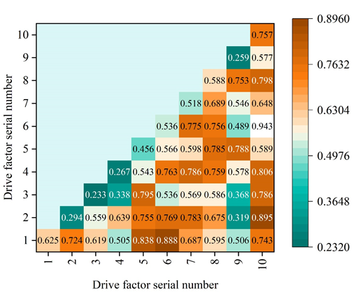
After in-depth analysis, we found that the interaction between any two factors exceeded the role of a single factor in affecting spatial differentiation, which indicated that the factors did not affect spatial differentiation in isolation. The driving factors numbered 1-10 represent the ecological land area, population density, \(\mathrm{\ge}\)10\(\mathtt{{}^\circ\!{C}}\) cumulative temperature, soil erosion, rainfall, elevation, per capita GDP, road density slope, and Normalized Vegetation Index (NDVI), respectively, and from the interaction type, the two-factor augmentation and nonlinear augmentation types dominate, which proves that the spatial differentiation of the CES in Ganzhou district is the result of the joint action of multiple factors. This fully proves that the spatial differentiation of CES in Ganzhou district is the result of multi-factors. It should be noted that the interaction between the ecological land area ratio and other factors significantly exceeds the interaction between other factors in terms of driving force, and also shows strong interaction within the natural factors. The highest value of explanatory power is the ecological land area index \(\mathrm{\cap}\) soil erosion, which has an explanatory power of 0.943. The interaction between natural and social factors also exerts a strong influence on the spatial differentiation of ecological values. The average land GDP \(\mathrm{\cap}\) ecological land area index (q-value 0.895) soil erosion \(\mathrm{\cap}\) population density (q-value 0.888), elevation \(\mathrm{\cap}\) population density (q-value 0.838), and road density \(\mathrm{\cap}\) ecological land area index (q-value 0.806), which have an explanatory power greater than 80%, have a strong explanatory power for the spatial differentiation index of the CES, and the interaction effect is significant. The degree of interaction among the other factors was below 80%, but still had a large effect on the ecosystem service value divergence, again indicating that the divergence of CES in Ganzhou District was the result of multi-factor interaction.
Firstly, two sets of time series data of X and Y were prepared, X is the area share of each land use type in the current township unit, and Y is the comprehensive ecosystem service index of the current township unit. Eviews software was used to carry out Granger causality analysis on the evolution of land use spatial structure and ecosystem service value in Ganzhou District, and Granger causality test was carried out on X and Y. Both Pearson coefficients were negative, and the P value was less than 0.05. X was the Granger cause of the change of Y at the 5% significance level, and the two were highly correlated. This proves that land use structure is the Granger cause of changes in the integrated ecosystem service index.
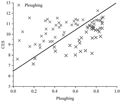
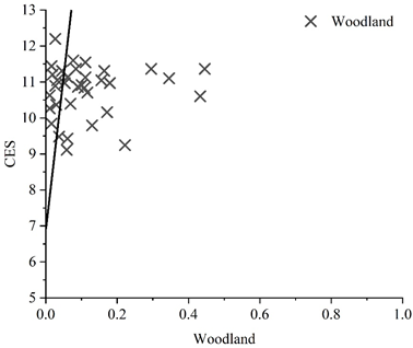
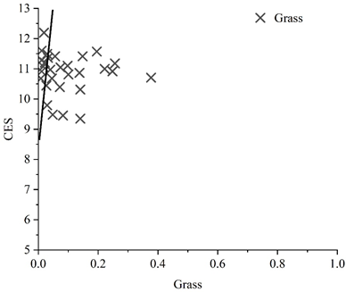
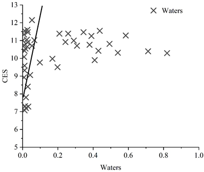
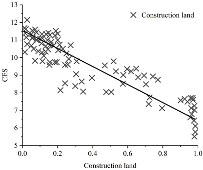
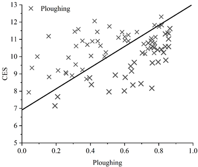
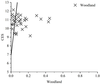
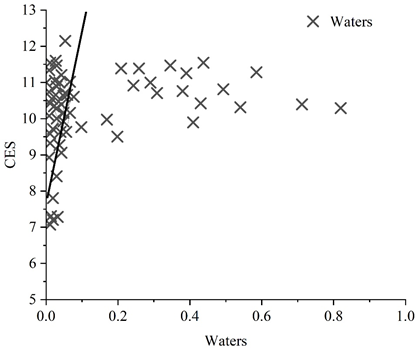
Eviews software was used to analyze the data in 2012 and 2022 by linear regression analysis, and Figures 2–6 show the results of regression analysis for cropland, forest land, grassland, watershed, and construction land in 2012, and Figures 7–11 show the results of regression analysis for cropland, forest land, grassland, watershed, and construction land in 2022, respectively. Among the five land use types, the multi-year average coefficient X of construction land is -4.24, which is the only land use type with an X value less than 0. The amount of unused land is very small, so it is not analyzed. The land use types in descending order of X coefficient are: grassland, forest land, cropland, watershed, and construction land.
From the land use status of the two periods and the average value of multi-year X coefficients, the X coefficient of grassland is the largest, 7.99, indicating that grassland has the most significant impact on the CES index. Taking the response equation of grassland in 2022 as an example: Y=9.4105+8.2577X for calculation, it is assumed that a 1% increase in the proportion of grassland area will make the value of ecosystem services increase by 17.6682%. Grassland has an obvious role in improving ecosystem services and biodiversity, so it is necessary to increase the area of grassland in an orderly manner on the basis of protecting the original grassland area. In addition to protecting existing grasslands and minimizing the disturbance of grasslands by human activities, efforts should be made to convert other lands to grasslands, thereby increasing the value of ecosystem services.
The X coefficient of forest land is second only to that of grassland, and it should be implemented in an orderly manner to return farmland to forests and grassland, delineate protected areas for forest land, limit the impact of human activities on forest land, and maintain ecosystem stability and integrity.
Construction land is the only land type showing negative correlation, and the absolute value is large, indicating that the increase of construction land will lead to a significant decrease in the CES index. Taking the response equation of construction land in 2022 as an example: (Y=11.3893-4.0859X) for calculation, it is assumed that a 1% increase in the area share of construction land will make the value of ecosystem services decrease by 7.3034%. It can be seen that in the expansion of construction land, usually accompanied by ecological damage and environmental pollution problems, resulting in a certain degree of loss of ecosystem service index. Therefore, in land use and development and construction, the scope and limitations of construction land should be clarified, the scale and layout of new construction land should be controlled, and it should be ensured that the construction land realizes reasonable and orderly expansion behavior within the urban development boundary.
On the whole, cultivated land, forest land, grassland, water area and ecosystem service value show a positive correlation, and the above land types are reasonably protected, while construction land shows a negative correlation, and the uncontrolled expansion of construction land should be strictly controlled so as to promote the further development of ecosystem service value.


The recognition of rights by law is the strongest protective measure for citizens to realize their rights. Under the influence of the long-standing urban-rural dual development model, the development paths of China’s rural and urban areas have resulted in differentiated choices, and the resulting great differences in the ecological environment between urban and rural areas have also become a relatively serious social problem at the present time.
Therefore, it is necessary to adopt targeted and specialized legislation to address the different characteristics of urban and rural environmental problems, and to establish the environmental rights of peasants in legislation, so that the environmental rights of peasants can be elevated to the height of the law and protected. Taking the environmental rights of peasants as the basis, taking into full consideration the special needs of peasants for the ecological environment as well as the actual characteristics of the rural geographical environment, and then constructing laws and systems related to rural ecological environmental protection, such as rural water resources and environment, the ecological environment of the soil, the prevention and control of pesticide and chemical fertilizer pollution, the pollution of rural household wastes, and the pollution of agricultural wastes, in order to find a legal basis for the protection of the protection of the ecological environment of the countryside. Strive to realize the legality, legitimacy and operability of the protection of rural ecological environment.
Both farmers and urban residents have the right to enjoy the good results of ecological environmental protection. The development and progress of cities cannot be separated from the countryside, and the protection and improvement of the rural ecological environment cannot be separated from the ecological compensation of cities to the countryside, so the protection of the rural environment must be carried out in an integrated and coordinated manner. In order to solve the inequality between urban residents and farmers in terms of environmental rights, we need to establish and improve the ecological compensation system for farmers, in the hope that the design of the system can realize a win-win situation between economic development and environmental protection, redistribute the benefits between urban ecological beneficiaries and rural victims, and protect the interests of farmers fundamentally.
Legal aid is a legal system in which the legal aid agencies established by the Government organize legal service agencies and legal service personnel to provide legal services to citizens who are in financial difficulty or to those involved in special cases, with a reduction or exemption of service fees. “It is a major shift in the position of justice from seeking the best interests of the greatest number of people to caring for the most disadvantaged in society.” As a new and artificially created vulnerable group in the distribution of environmental resource rights and interests, the protection of the interests of vulnerable groups with environmental resource rights and interests is not only a matter of resource utilization and environmental rights, but also a matter of social equity and justice. In the era of “capital hostage to environmental governance”, rural environmental problems are often combined with poverty, with a high degree of coupling in terms of geographical distribution. Poor farmers have little ability to defend their rights when their environmental rights and interests are violated, not simply because of a lack of legal knowledge and awareness, but also because of a lack of ability to defend their environmental rights due to their weak economic power. In response to this problem, existing environmental legislation is basically in a state of silence, and in practice, judicial remedies for the protection of environmental rights have no way to operate and protect them. As the legal proverb says, “A right is not a right without a remedy”, which makes clear the importance of remedies to rights. In the scope of the right to relief, the legislative establishment of the environmental rights of peasants is not sufficient to enable peasants to enjoy environment-related rights and interests; the law must also give real and concrete value to the realization of the right to the system, expand the legal aid system to the environmental rights of peasants, and regulate and dissolve the disadvantageous position based on chance, resource endowment and other contingent factors by means of a skewed allocation of resources.
In the field of environmental protection, citizen participation refers to the participation of citizens in all decision-making activities related to environmental interests through certain procedures or channels, in accordance with the rights and obligations conferred by national environmental protection laws and regulations. As far as the ecological environmental protection of farmers is concerned, the differences in the rural ecological environment should be fully taken into account, combined with the characteristics of rural environmental protection, and the participation of farmers in the environment should be fully guaranteed, i.e., with the participation of farmers as the core, they can independently choose the appropriate mode of production and way of life, and realize the management of the rural ecological environment directly or indirectly, so as to enhance the sense of mastery of the farmers, and to make the protection of the rural ecological environment more mass and practical, and to further increase the transparency of law enforcement in the rural environment. At the same time, the transparency of rural environmental law enforcement should be further increased, rural environmental law enforcement activities should be placed under the supervision of society as a whole, and a public system of administrative law enforcement in rural environments should be promoted, the principle of democratic openness should be implemented, the farmers’ right to know about the environment should be fully guaranteed, and the conditions should be created for the participation of farmers in ecological environmental protection and ecological environmental management activities.
Taking Ganzhou District as the study area, this paper explores the distribution characteristics of each type of rural ecology through a variety of geospatial analysis methods and tools, revealing the spatial heterogeneity of the ecosystems in Ganzhou District and the driving forces behind them, thus improving the environmental legal protection system of the region.
The total number of rural ecosystems in the farmland ecology category is the largest, which is closely related to the long history and splendid civilization of Ganzhou District. Among them, forest ecology rural ecology has the most obvious direction of distribution, and watershed ecology rural ecology has the highest concentration of distribution. The Z-value of the five types of rural ecology was less than -2.58, indicating that the five types of rural ecology were not significantly clustered in space.
The most significant factor affecting the change of the comprehensive ecosystem service index is the proportion of ecological land area, and its contribution rate is 50%. The next most significant factors were population density, cumulative temperature, soil erosion and rainfall, all with a contribution of 0.4 or more.
The results of interaction detection showed that the spatial differentiation of CES in Ganzhou district was dominated by multi-factor interaction types. Among the land use types, the X coefficients were, in descending order, grassland, forest land, cropland, water, and construction land, and the X average coefficient of grassland was the largest, 7.99, and its effect on the CES index was the most significant. The X average coefficient of construction land is the only negative value, showing a negative correlation with the CES index, suggesting that the expansion of construction land should be strictly controlled, and the protection of ecosystems should be realized by improving legislation on ecological environmental protection, ecological compensation system and legal aid.